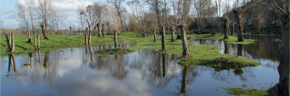
Water grasslands in France
27.09.2017, by Bénédicte Gaillard
Research: Bénédicte Gaillard & Alexandra Kruse; upload: Bénédicte Gaillard: The entries are still in process
Most of these meadows have always been maintained by traditional and extensive practices such as grazing and mowing for the production of hay.
Assemblée Permanente des Chambres d’Agriculture (2014) Concilier agriculture et zones humides, http://www.zones-humides.eaufrance.fr/sites/default/files/apca_exe_36_pages_zh-02-04-14_bat_5_0.pdf
Broyer. J. (1997) Incidence des fenaisons tardives sur la valeur nutritive des fourrages dans les prairies inondables de la vallée de la Saône, Fourrages 150, 225-234
Bernard Clément & Edward Maltby (1996) Quelques facteurs de la biodiversité végétale dans les prairies humides des corridors fluviaux, Acta Botanica Gallica, 143:4-5, 309-316,
DOI: 10.1080/12538078.1996.10515728
Fiche milieu naturel n°2 : Les prairies humides
Frédérique Grévilliot & Serge Muller (1996) Etude de l'impact des changements des pratiques agricoles sur la biodiversité végétale dans les prairies inondables du Val de Meuse: présentation méthodologique et premiers résultats, Acta Botanica Gallica, 143:4-5, 317-338, DOI: 10.1080/12538078.1996.10515729
Institut Français de l’Education http://eduterre.ens-lyon.fr/thematiques/hydro/zones_humides/html/fichstatut
Ministère de l’Alimentation, de l’Agriculture et de la Pêche (2010) http://agriculture.gouv.fr/sites/minagri/files/documents/pdf/2-214I2-BN-prairieshumides.pdf
http://www.glossaire.eaufrance.fr/concept/prairie-inondable
http://www.eaufrance.fr/spip.php?page=concept&id_concept=2353
http://www.pole-zhi.org/prairie-inondable
http://www.angers.fr/fileadmin/plugin/tx_dcddownloads/Milieux_01.pdf
http://www.areas-asso.fr/wp-content/uploads/2016/11/19-prairie-inondable.pdf
http://www.centre.chambagri.fr/cd_ibis/xdocs/pdf/pratiques/prairies.pdf
http://www.oncfs.gouv.fr/IMG/article_PDF/article_a1045.pdf
http://www.aprr.com/sites/www.aprr.com/files/carnet-autoroute-n6.pdf
http://www.eptb-vilaine.fr/site/telechargement/interreg/WOW/Rapport-final_WP4-1-FR.pdf
Some water meadows in France are possibly flooded all year long, such as for example in the Loir, Eure, Fouzon and Loire region or in Sologne, Perche, Brenne or Boischaut.
Meadows on the Loire banks between Nantes and Montsoreau currently occupy around 50% of the territory of the Loire Valley. These are “semi natural” agricultural spaces used by approximately 1.000 exploitations with more or less extensive bovine systems. The permanent meadow remains the best compromise between the agricultural interests and the environmental interests. The preservation of flood meadows is essential due to the multiple interests it presents: expanding flood areas, preservation of the water resource, diversity and biological richness, strong landscape and social identity, feed supplies.
A humid zone is a transition space between water and earth. It is recovered by shallow water permanently or temporarily. It is a very varied ecosystem that forms in fringes of rivers, marshes, lakes, estuaries, deltas, bays or sources. The Environmental Code defines them as “the lands, harvested or not, usually flooded or water-logged with fresh, salt or brackish water permanently or temporarily. Vegetation, when it exists, is dominated by hygrophilous plants during at least a part of the year”.
Water meadows can be categorised in two groups: (1) the hygrophile meadows that can be found at low topographical levels with long periods of floods and that remain humid even in Summer; (2) the meso-hygrophile meadows that are located at higher topographical levels than the previous ones, thus limiting the flooding periods.
Like all open environments, the agricultural decline has often led to their draining and redevelopment in cereal, corn or poplar crop. For the sectors with poorer soils, the abandonment, often synonym of evolution towards a tall grass meadow then towards the progressive afforestation, has not always been more favourable to them. Agricultural decline or intensification or also urbanisation have led since the 1960’s to the disappearance of more than half of these meadows at national scale.
Meadows on the Loire banks between Nantes and Montsoreau currently occupy around 50% of the territory of the Loire Valley. These are “semi natural” agricultural spaces used by approximately 1.000 exploitations with more or less extensive bovine systems. The permanent meadow remains the best compromise between the agricultural interests and the environmental interests. The preservation of flood meadows is essential due to the multiple interests it presents: expanding flood areas, preservation of the water resource, diversity and biological richness, strong landscape and social identity, feed supplies.
The agricultural intensification and extensification on the flood plain vegetation led to the disappearance of two prairial types, the Bromus erectus meadows and the Filipendula ulmaria formation, to the impoverishment of the floristic diversity with the enhancement of the fertilisation, to the decrease of oligotrophic (Unum catharticum, Ophioglossum vulgatum. Succisa pratensis) and meso-oligotrophic (Briza media, Rhinanthus minory species. On the contrary, the restoration of the floristic biodiversity after the settlement of extensive practises is slow and strongly influenced by the climatic fluctuations.
The Region Basse-Normandie and the European Agricultural Fund for the Rural Development (FEADER) act for the preservation of the water meadows in the Cotentin and Bessin wetland. Both areas cover 28.000 ha included in the much larger Regional Natural Park (145.000 ha). This Natura 2000 territory crosses the Cotentin peninsula. Flooded in Winter and squared by rivers in Spring these wetlands host a typical ecological heritage of the water meadows. In the frame of this project, contracts for 5 years are signed with agricultural exploitations. The farmers engage to adopt agricultural techniques respectful of the environment. These measures, called “Mesures agroenvironnementales territorialisées (MAEt)”, include for example the maintenance of permanent meadows, the limitation and even the suppression of fertilisation and phytosanitary treatments. The agricultural practices for the wetland management are mainly dairy farming, mowing, grazing, maintenance of sceptic systems.
18 territorial actions have taken place with the Chambers of Agriculture and various local institutions (département, région..) and farmers: in the catchment areas Loire-Bretagne (Briance basin, Region Bretagne, Angevin Valleys, Loire meadows in the Saumurois, Mothe meadows, Loire banks, Creuse water meadows, Erdre wetlands, Grand Lieu lake), in the catchment areas Artois-Picardie (Somme bay, Scarpe-Escault lowland), in the catchment areas Seine-Normandie (SAGE de la Sélune et Douve-Taute), in the catchment areas Rhône-Méditerrannée Corse (Languedoc Roussillon, Arc catchment area), in the catchment areas Réal de Jouques (Ognon middle valley and Colombine valley), in the catchment areas Adour-Garonne (Brouage wetlands, Tarn, Lozerian Aubrac).


